How often have I paused on every charm,
The sheltered cot, the cultivated farm,
The never-failing brook, the busy mill,
The decent church that topt the neighbouring hill,
The hawthorn bush, with seats beneath the shade,
For talking age and whispering lovers made!
The Deserted Village ~By Oliver Goldsmith, 1770
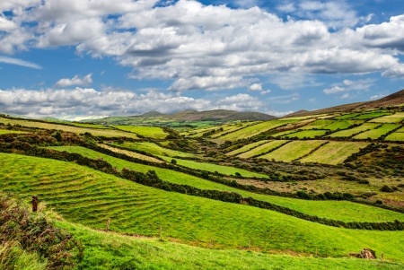
The scenery, the history of the Irish touches this RecordClick genealogist. There are some sheltered glens and other well defined fields facing the ocean’s winds. For the family historian seeking land records in Ireland, though, the scenery may not be so romantic. Land ownership in Ireland bears little resemblance to the United States, beginning with land descriptions.
When working with land locations in any country, the one similarity is in the best process to follow – begin with the big and work to the small. In the U.S., the location is narrowed by state, county, and civil township. In Ireland, there are provinces, counties, baronies, parishes (don’t confuse civil and ecclesiastical), and townlands. The provinces are: Ulster, Leinster, Munster, and Connaught. The other land divisions can be a bit confusing:
- Counties. The first counties were created in the early 1200s. By the 1500s, there were 32, and that number remained until the Local Government (Ireland) Act 1898 was passed. The boundaries of Counties Galway, Clare, Mayo, Roscommon, Sligo, Waterford, Kilkenny, Meath, Louth and others were changed, and County Tipperary was divided into two regions: North Riding and South Riding. Areas of the cities of Belfast, Cork, Dublin, Limerick, Derry, and Waterford were carved from surrounding counties to become county boroughs.
- Baronies. These are based on Gaelic family land holdings. There are 325 baronies in all of Ireland, and they were turned into civil divisions by the English in the 1800s for the purpose of land valuation.
- Parishes. There are two types of parishes in Ireland: ecclesiastical and civil. The boundaries of the two do not coincide. The ecclesiastical parish is a smaller unit of land, and the civil parish is used for land valuation.
- Townlands. Smaller yet, these are located in a rural section of a parish. The average area is 350 acres, and there are more than 60,000 in all of Ireland.
Irish research would be a lot easier for a genealogist if boundaries remained the same. Unfortunately, that is not the case. Between about 500-1100, Ireland was divided into little kingdoms with the normal turf disputes. When England invaded in about 1100, shires or counties were created. Even then, as needs changed, borders may have, as well. There are two important years you should remember when conducting Irish genealogy:
- 1898 – Local Government (Ireland) Act. A number of county lines were altered.
- 1920 – Government of Ireland Act. This act created a partition between the Republic of Ireland and Northern Ireland.
To make Irish research even more challenging, the family genealogist needs to keep in mind that, because of the hierarchical nature of land ownership in Ireland, many individuals were not in a situation to own land. Instead, they had to lease their plot from the noble landowner. While a deed may or may not exist, there may still be a paper trail:
- Tithe Applotment Books. The Books comprise land surveys in each civil parish. The surveys, compiled between 1823 and 1838, were based on the average price of wheat and oats for the seven years up to 1823, which determined the amount of tithes paid to the Church of Ireland. The tithes or taxes were resented by those not belonging to the Church and abolished in about 1869. The Books are a good way to determine land owners. Images are online at FamilySearch.
- Griffith’s Valuation. In response to the potato famine, Griffith’s Valuation determined the liability to pay Poor rate for the support of the poor and destitute. Carried out between 1848 and 1864, Griffith’s Valuation provides information on where people lived and the property they possessed. It is more comprehensive in the number of people it lists than the Title Applotment Books. The information has been digitized and is online at Ask About Ireland. The free website is a collaboration between Ask About Ireland and the Cultural Heritage Project, offering online publication of original, unusual, and unique material from Irish resources. Griffith’s Valuation is also available on Ancestry with a world explorer membership.
- Estate Papers. By far, the majority of the Irish population lived as tenant farmers on estates. They left documents in the form of leases and deeds, account books, and correspondence in the form of Estate Papers. Much of this information has found its way to the National Library of Ireland, the National Archives of Ireland, and the Public Record Office of Northern Ireland (PRONI).
If researching Irish land records leaves you a bit lost, consider hiring a professional genealogist at RecordClick. We have family historians in Ireland who can help you break through that moss-covered wall from County Antrim to County Wicklow. Our expert genealogists can assist in finding that one certain document or creating your Irish family tree.